

Puerto Princesa Underground River
Avoid the trial-and-error of the permit process by booking your Puerto Princesa Underground River Tour through a travel agency that can expertly handle it for you, allowing you to spend your vacation exploring and enjoying this beautiful piece of the world’s best island. With a daily limit of tourists set by the local goverment, it is highly recommended that you secure your entry permit to the Puerto Princesa Subterranean River before embarking on your journey to Palawan. The Philippine Government is dedicated to preserving this unique treasure and has implemented a permit system for visitors.
Inquire/Check Slot Availability
Under Ground River Tour
Transfer Service
Private/Shared | Puerto Princesa, El Nido, and San Vicente (Port Barton & Long Beach)

Welcome to the beautiful city of Puerto Princesa, nestled within the lush landscapes of Palawan, part of MIMAROPA Region in Philippines. As your trusted online travel guide, we invite you to embark on a journey of discovery and adventure in this tropical paradise. From the breathtaking Palawan Underground River, officially known as the Puerto Princesa Subterranean River National Park, to the stunning Honda Bay and other attractions, there is no shortage of wonders to behold in this tourist destination. Whether you prefer the luxury of resorts and hotels or seek more budget-friendly accommodations, PPC has it all! With a wide range of packages, tours, and car rental deals, as well as Puerto Princesa International Airport flights and van transfer services to island hopping excursions, this site provides everything you need to know to fully immerse yourself in this remarkable place. So, come, explore, and allow the Philippines to leave a lasting impression on your heart with this stunning piece of paradise.

Accommodations
Day Tour
Packages

Flights & Schedule

Transfer Service

Car Rental
A Travel Guide to the Heart of Palawan, Philippines: Puerto Princesa Hotels, Airport, City Tour, Honda Bay Island Hoppig, Underground River Tour Packages & More!
Puerto Princesa City, the vibrant capital of Palawan, Philippines, serves as a gateway to the island’s natural wonders and cultural heritage. Strategically located in the MIMAROPA region, it is nestled at the heart of Palawan, making it an essential hub for travelers seeking to explore the island’s myriad attractions. The city is renowned not only for its breathtaking landscapes but also for its rich history and cultural significance, which collectively contribute to its unique charm.
Geographically, Puerto Princesa is positioned along the western coast of Palawan, facing the Sulu Sea. This prime location offers easy access to various natural attractions, including pristine beaches, lush forests, and the world-famous Puerto Princesa Underground River, also known as the Puerto Princesa Subterranean River National Park. This natural marvel, recognized as a UNESCO World Heritage Site, is a testament to the city’s commitment to preserving its ecological treasures.
Historical records suggest that Puerto Princesa has been a significant settlement for centuries, with its roots tracing back to pre-colonial times. It has evolved through the eras, from a humble fishing village to a bustling urban center. The city’s name, derived from a Spanish princess, reflects its colonial past and the influence of Spanish culture, which is still evident in its architecture, festivals, and traditions.
Culturally, Puerto Princesa is a melting pot of various ethnicities and traditions. It is home to the indigenous Tagbanua people, whose customs and way of life add depth to the city’s cultural tapestry. Additionally, the influx of migrants from different parts of the Philippines has created a diverse community, enriching the local culture with a blend of customs, cuisines, and arts. Festivals like the Baragatan sa Palawan celebrate this diversity, showcasing the vibrant spirit of the city.
In essence, Puerto Princesa is not just a city; it is a living museum of natural beauty, history, and culture. Its strategic location, historical depth, and cultural richness make it a must-visit destination for anyone exploring Palawan and the broader Philippines. Whether you’re staying at one of the many hotels in Puerto Princesa Palawan or exploring the city’s numerous attractions, this captivating city promises an unforgettable experience.
Palawan: Renowned as One of the World’s Best Islands
Palawan, the stunning archipelago where Puerto Princesa is located, has consistently captured the world’s attention with its breathtaking landscapes and pristine beaches. Frequently hailed as one of the most beautiful islands globally, Palawan boasts a rich tapestry of natural wonders that leave visitors in awe. From its crystal-clear waters to its lush jungles and dramatic limestone cliffs, the island’s diverse ecosystems are a testament to nature’s splendor.
One of Palawan’s crowning jewels is the Puerto Princesa Subterranean River National Park. This UNESCO World Heritage Site is home to the famous Puerto Princesa Underground River, a marvel of nature that winds through an extensive cave system, offering a unique and awe-inspiring experience for adventurers. The park’s rich biodiversity, including various endemic species of flora and fauna, further cements its status as a must-visit destination.
Palawan’s accolades are numerous, with travel enthusiasts and publications frequently ranking it among the top island destinations in the world. Its pristine beaches, such as those found in El Nido and Coron, offer idyllic settings for relaxation and exploration. Whether you’re snorkeling in vibrant coral reefs, kayaking through hidden lagoons, or simply basking on sun-kissed sands, the island’s natural beauty provides a backdrop for unforgettable experiences.
Moreover, Puerto Princesa, the capital city of Palawan, serves as the gateway to these natural wonders. The city is well-equipped to cater to travelers, with a range of hotels in Puerto Princesa Palawan Philippines that offer comfortable accommodations and convenient access to tourist attractions. Visitors can enjoy the city’s vibrant culture, delicious cuisine, and warm hospitality while planning their adventures around the island.
In essence, Palawan’s global recognition as a paradise is well-deserved. Its unparalleled natural beauty, coupled with the unique experiences it offers, makes it an essential destination for any traveler’s bucket list. Whether you’re exploring the depths of the Puerto Princesa Underground River or lounging on a secluded beach, Palawan promises a journey filled with wonder and discovery.
Exploring the Puerto Princesa Subterranean River National Park – a UNESCO World Heritage Site
The Puerto Princesa Subterranean River National Park, often referred to as the “Palawan Underground River,” stands as a testament to the natural wonders of Puerto Princesa, Palawan. Recognized as a UNESCO World Heritage Site, this subterranean marvel stretches over 8.2 kilometers, making it one of the longest underground rivers in the world. The river flows directly into the South China Sea, creating a unique landscape that blends terrestrial and marine ecosystems.
Geologically, the Puerto Princesa Underground River is a spectacle, characterized by its karst limestone landscapes. Visitors can expect to navigate through intricate cave formations, including stalactites and stalagmites that have formed over millions of years. The cave system also features large chambers, some of which reach up to 120 meters in width and 60 meters in height, offering an awe-inspiring sight.
Beyond its geological significance, the park is a biodiversity hotspot. It is home to over 800 plant species, 195 bird species, and various mammals, reptiles, and marine life. Notable residents include the Palawan hornbill, the Palawan bearcat, and the endangered Philippine cockatoo. This rich biodiversity underscores the park’s importance in conservation and ecological studies.
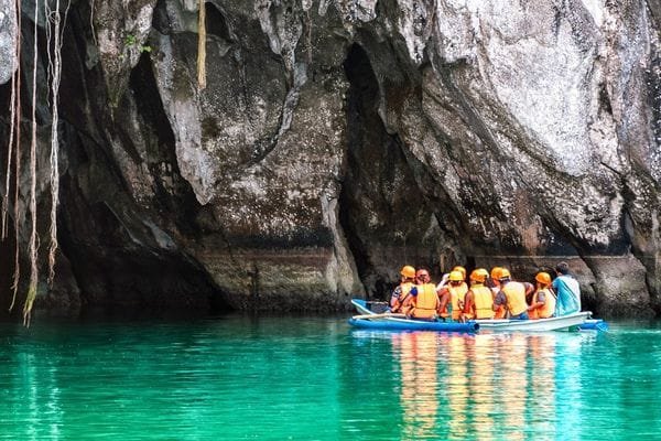
For those planning to visit, there are several tour options available. Guided boat tours are the most popular, providing an immersive experience as you paddle through the dark, echoing chambers of the underground river. Detailed commentary from knowledgeable guides enhances the experience, shedding light on both the natural and cultural history of the area. Be sure to book your tours in advance, as daily visitor numbers are regulated to preserve the delicate ecosystem.
Accessing the park is relatively straightforward. It is located about 80 kilometers north of the Puerto Princesa Airport, with several hotels in Puerto Princesa City offering transport packages. Accommodations range from budget-friendly options to more luxurious hotels Puerto Princesa Philippines has to offer, ensuring a comfortable stay for all visitors. With proper planning and respect for the natural environment, a visit to the Puerto Princesa Subterranean River National Park promises an unforgettable adventure in the heart of Palawan.
Traveling to Puerto Princesa Palawan Philippines
Puerto Princesa International Airport, the largest in Palawan, serves as your gateway to this stunning island province. The airport is well-connected, offering numerous flight schedules from major airlines, ensuring convenience and flexibility for travelers. Major carriers such as Philippine Airlines, Cebu Pacific, and AirAsia operate frequent flights from key cities like Manila, Cebu, and Davao, making it easier than ever to reach this tropical paradise. The airport’s modern amenities and efficient services ensure a smooth travel experience, whether you’re arriving or departing.
Once you land at Puerto Princesa International Airport, you’ll find that Puerto Princesa is not just a destination in itself but also a strategic jump-off point for exploring the broader Palawan region. From here, you can easily access renowned attractions such as El Nido, famous for its stunning lagoons and pristine beaches, and the less-traveled yet equally captivating Balabac, known for its crystal-clear waters and rich marine biodiversity. Additionally, Port Barton in San Vicente, with its charming, laid-back vibe, is just a few hours away, perfect for those seeking a quieter, more serene escape.
Travelers will find a variety of hotels in Puerto Princesa Palawan Philippines, offering a range of accommodations to suit all preferences and budgets. Whether you’re looking for a luxurious hotel in Puerto Princesa City or more modest hotel accommodation in Puerto Princesa, the options are plentiful. Many hotels provide shuttle services to and from Puerto Princesa Airport, adding an extra layer of convenience to your travel plans.
Overall, Puerto Princesa serves as an excellent base for your Palawan adventure. With its well-connected airport, diverse flight routes, and proximity to other enticing destinations, it ensures that your journey is as enjoyable as your stay. So, pack your bags and let Puerto Princesa be your first stop in exploring the natural wonders of Palawan, Philippines.
Accommodation Options in Puerto Princesa: Luxury Hotels, Resorts, Tourist Inns, Lodging Houses, Motels, Hostels, Bed and Breakfasts (B&Bs), Guesthouses, Vacation Rentals, Boutique Hotels, Eco-lodges, Farm Stays
Puerto Princesa, the bustling capital of Palawan, Philippines, offers a plethora of accommodation options catering to the diverse needs of travelers. Whether you are a backpacker seeking budget-friendly lodgings or a luxury traveler in search of a 5-star experience, Puerto Princesa has something for everyone.
For budget-conscious travelers, there are numerous hostels and backpacking lodges scattered around the city. These establishments often provide basic amenities such as Wi-Fi, communal kitchens, and shared dormitory-style rooms. A popular choice among backpackers is the Banwa Pension, known for its cozy atmosphere and convenient location near the Puerto Princesa Airport.
Mid-range accommodations in Puerto Princesa offer a balance of comfort and affordability. Hotels like the Aziza Paradise Hotel and Canvas Boutique Hotel provide well-furnished rooms, swimming pools, and on-site dining options. These hotels in Puerto Princesa Palawan are ideal for families and couples looking for a comfortable stay without breaking the bank.
For those seeking luxury, Puerto Princesa boasts several high-end resorts and 5-star hotels. The Princesa Garden Island Resort and Spa and the Astoria Palawan stand out for their exceptional service, luxurious amenities, and stunning beachfront locations. These resorts often feature private villas, spa services, and gourmet dining options, providing a truly indulgent experience.
Travelers interested in exploring the natural wonders of Puerto Princesa will find various eco-friendly resorts and lodges. Accommodations like the Daluyon Beach and Mountain Resort offer unique experiences such as guided tours to the Puerto Princesa Underground River, a UNESCO World Heritage Site. Staying at these eco-resorts allows guests to immerse themselves in the natural beauty of the Puerto Princesa Subterranean River National Park.
Whether you are looking for budget-friendly lodgings, mid-range hotels, or luxury resorts, Puerto Princesa has a wide array of options to suit every preference and budget. Each type of accommodation offers distinct features and amenities, ensuring a memorable stay in this captivating city.
Essential Services and Amenities in Puerto Princesa City Palawan
Puerto Princesa, often referred to as the gateway to the stunning Palawan island, is equipped with a comprehensive range of essential services and amenities to ensure a comfortable stay for both tourists and residents. Whether you are staying in one of the many hotels in Puerto Princesa Palawan or exploring the city, having access to essential services is paramount.
Banking services are readily available with numerous branches of both local and international banks situated in key locations throughout the city. These institutions offer a wide array of services including currency exchange, ATMs, and financial advice, making it convenient for travelers to manage their finances.
Healthcare is another critical aspect where Puerto Princesa excels. The city hosts various hospitals and clinics such as the Adventist Hospital Palawan and Ospital ng Palawan, which provide top-notch medical care. For minor health concerns, numerous drug stores are spread across the city, ensuring that medical supplies and over-the-counter medications are within easy reach.
Convenience stores and supermarkets like Robinsons Place Palawan, SM City Puerto Princesa, and NCCC Mall offer a plethora of goods ranging from groceries to travel essentials, making everyday shopping effortless. These establishments are often located near popular hotels in Puerto Princesa City Palawan, adding to the convenience for visitors.
Education and government services are also well-represented. Institutions like Palawan State University cater to the educational needs of the local population and expatriates, while government offices such as the City Hall and various barangay offices provide essential administrative services.
All these amenities contribute to the overall convenience and comfort of staying in Puerto Princesa. Whether you are visiting the famous Puerto Princesa Underground River or simply enjoying the city, the availability of essential services ensures a hassle-free and enjoyable experience.
Top Attractions and Activities in Puerto Princesa: What to Do, What to See
Puerto Princesa, the capital of Palawan, is a treasure trove of natural wonders and exciting activities. Dominating the list of must-visit sites is the world-renowned Puerto Princesa Underground River. This UNESCO World Heritage site, also known as the Puerto Princesa Subterranean River National Park, offers visitors a unique opportunity to explore a labyrinth of caves and waterways. The underground river tour is a mesmerizing journey through stunning rock formations and an ecosystem teeming with diverse wildlife, making it a pivotal experience for any traveler.
Beyond the subterranean marvels, a city tour of Puerto Princesa offers a blend of historical, cultural, and natural attractions. The tour usually includes stops at the Immaculate Conception Cathedral, a beautiful Spanish-era church, and Plaza Cuartel, a historical site with deep wartime significance. Don’t miss the chance to explore the Palawan Wildlife Rescue and Conservation Center, where you can get up close with crocodiles and other native species. The city tour is an excellent way to gain insight into the rich heritage and vibrant life of Puerto Princesa.
For those who crave the sun and sea, Honda Bay island hopping is an unmissable adventure. Honda Bay offers a cluster of idyllic islands, each with its unique charm. Make sure to visit Pandan Island for its pristine beaches and snorkeling spots, Starfish Island for its abundant sea stars, and Luli Island, which appears and disappears with the tide. The clear waters and vibrant marine life make Honda Bay a paradise for beach lovers and snorkeling enthusiasts alike.
Additionally, Puerto Princesa is home to several other natural attractions worth exploring. Visit the serene Nagtabon Beach for a more laid-back beach experience, or trek to Olangoan Falls for a refreshing dip in its cool waters. For spelunking enthusiasts, the Ugong Rock Adventures offers thrilling cave explorations combined with zip-lining. Each of these attractions adds a unique flavor to your Puerto Princesa adventure, ensuring a diverse and memorable experience.
Recommended Booking & Travel Agency: D’Palawan Travel and Tours
For travelers seeking an unforgettable experience in Puerto Princesa, D’Palawan Travel and Tours stands out as a top recommendation. This well-regarded travel agency is committed to providing value-for-money tour packages that cater to a diverse range of interests and preferences. Whether you are planning to explore the enchanting Puerto Princesa Underground River or unwind in the serene landscapes of San Vicente (Port Barton), D’Palawan Travel and Tours ensures a seamless and enriching journey.
The agency offers a variety of tour packages that include must-visit destinations in Puerto Princesa Palawan. From guided tours of the Puerto Princesa Subterranean River National Park to island-hopping adventures around Honda Bay, each itinerary is meticulously planned to provide a comprehensive experience of Palawan’s natural beauty. Additionally, their packages often encompass visits to lesser-known yet equally captivating spots, ensuring that travelers get a well-rounded view of the region.
One of the standout features of D’Palawan Travel and Tours is their commitment to customer satisfaction. Testimonials and reviews from previous clients highlight the agency’s professionalism, knowledgeable guides, and exceptional service. Many travelers have praised the ease of booking and the high-quality accommodations arranged by the agency, which often include some of the best hotels in Puerto Princesa City Palawan. These positive reviews underscore the agency’s dedication to making each trip memorable and hassle-free.
Moreover, D’Palawan Travel and Tours offers customized packages that can be tailored to the specific needs and preferences of their clients. Whether you are interested in eco-tours, cultural experiences, or adventure activities, the agency can craft a personalized itinerary that aligns with your interests. This flexibility ensures that every traveler can enjoy a unique and fulfilling experience in Palawan Puerto Princesa.
If you are planning a visit to Puerto Princesa or other parts of Palawan, consider partnering with D’Palawan Travel and Tours. Their expertise and commitment to excellence will undoubtedly enhance your travel experience, allowing you to fully immerse yourself in the wonders of this beautiful region.
For more information or to book a tour, you can visit their official website: www.DPalawanTravelAndTours.com
New7Wonders of Nature: Puerto Princesa Subterrenean River National Park
Located in the picturesque city of Puerto Princesa in Palawan, Philippines, the Puerto Princesa Underground River stands as a testament to nature’s grandeur. This subterranean marvel is globally recognized as one of the New7Wonders of Nature, drawing visitors from around the world who are eager to witness its awe-inspiring beauty. Renowned for its stunning limestone karst landscapes, the river winds through a series of majestic caverns, creating an ethereal experience for those who venture into its depths.
The Puerto Princesa Subterranean River National Park, which encompasses the underground river, is also a UNESCO World Heritage Site. This designation highlights its exceptional natural value and the importance of its conservation. Spanning over 22,000 hectares, the park is a haven for biodiversity, featuring lush forests, unique wildlife, and pristine beaches. Visitors can explore the river’s fascinating geological formations, including stalactites and stalagmites that have been sculpted over millennia.
As you embark on a journey to the Puerto Princesa Underground River, you’ll quickly understand why it is celebrated as one of the wonders of the world. The river’s underground passageways stretch for more than 8 kilometers, making it one of the longest navigable underground rivers globally. Its enchanting environment is further enhanced by the presence of rare species, such as the Palawan swiftlet and the endangered Philippine cockatoo, making it a paradise for nature enthusiasts and bird watchers alike.
Whether you’re drawn by the allure of its mystic caves or the rich biodiversity that thrives within the Puerto Princesa Subterranean River National Park, this natural wonder promises an unforgettable adventure. Join us as we delve deeper into the various aspects of this extraordinary site, uncovering the many facets that make it a must-visit destination for travelers from all corners of the globe.
Puerto Princesa Underground River Location and Accessibility
Situated in the heart of Palawan, Philippines, Puerto Princesa City is a central hub within the MIMAROPA region. This prime location makes it an ideal starting point for exploring the myriad attractions Palawan has to offer, including the renowned Puerto Princesa Subterranean River National Park, commonly referred to as the Puerto Princesa Underground River.
Reaching this stunning natural wonder is straightforward, thanks to the city’s well-connected transport links. The Puerto Princesa International Airport, located just a short drive from the city center, offers flights from major cities such as Manila, Cebu, and Davao. For those traveling from other parts of Palawan, the San Vicente Airport also provides convenient access, albeit with fewer flight options compared to Puerto Princesa International Airport.
Once you arrive in Puerto Princesa, getting to the underground river is relatively easy. A scenic journey of around 80 kilometers north of the city leads you to the small village of Sabang, the gateway to the Puerto Princesa Subterranean River National Park. From Sabang, visitors can embark on a short boat ride to the park entrance, adding to the adventure of the experience.
Puerto Princesa’s strategic location not only facilitates access to the underground river but also serves as a convenient jump-off point to other spectacular destinations in Palawan. Travelers often combine their visit to the Puerto Princesa Underground River with trips to the picturesque El Nido, known for its stunning limestone cliffs and crystal-clear waters, or the serene beaches of Port Barton. This connectivity enhances the overall appeal of Puerto Princesa as a travel destination, making it a must-visit for anyone exploring Palawan.
Puerto Princesa Underground River History and Facts
The Puerto Princesa Subterranean River National Park, often referred to as the Puerto Princesa Underground River, is a marvel of natural beauty and historical significance. Its discovery dates back to 1959 when a group of explorers stumbled upon this hidden gem nestled within the Saint Paul Mountain Range on the western coast of Palawan, Philippines. The river itself stretches for approximately 8.2 kilometers, making it one of the longest navigable underground rivers in the world.
Geologically, the Puerto Princesa Underground River is a product of millions of years of natural processes, including the dissolution of limestone by water, forming vast cave systems adorned with stunning stalactites and stalagmites. This formation has created a unique ecosystem that supports a diverse range of flora and fauna, some of which are endemic to the area.
In 1999, the Puerto Princesa Subterranean River National Park was inscribed as a UNESCO World Heritage Site, a testament to its outstanding universal value. This designation highlights the river’s importance not only to the Philippines but to the global community, recognizing its unique karst landscape, biodiversity, and the presence of significant natural phenomena.
Adding to its list of accolades, the Puerto Princesa Underground River was named one of the New 7 Wonders of the World in 2012. This recognition was the result of a global poll that celebrated the world’s most remarkable natural sites. The river’s inclusion in this prestigious list has elevated its status, attracting tourists from around the globe who are eager to witness its breathtaking beauty and rich history.
Apart from its natural allure, the Puerto Princesa Underground River holds cultural significance for the local communities. It is a symbol of pride and a source of livelihood, fostering a sense of stewardship and responsibility towards preserving this natural treasure for future generations.
Inside Underground River Palawan
Exploring the inner sanctum of Puerto Princesa Subterranean River National Park offers an unparalleled experience. As you embark on an underground river tour, the first sight that captures your attention is the stunning rock formations. These limestone structures have been meticulously carved over centuries by the flow of water, creating awe-inspiring stalactites and stalagmites that appear almost otherworldly. The dynamic interplay of light and shadow within the underground chamber accentuates the natural beauty of these formations, making each cavern seem like a hidden masterpiece.
As your boat glides deeper into the cave, you’ll encounter an array of unique wildlife. Bats hanging from the cathedral-like ceilings and swiftlets darting through the air are common sights, contributing to the cave’s vibrant ecosystem. Additionally, the underground river is home to various aquatic species that thrive in its dark, pristine waters. This biodiversity highlights the ecological significance of the site and underscores the importance of its conservation.
The overall ambiance inside Puerto Princesa Underground River is both serene and mysterious. The gentle lapping of water against the boat, coupled with the occasional drip from the cave ceiling, creates a tranquil soundscape. The cool, humid air is punctuated by the earthy scent of wet stone and mineral deposits, offering a sensory experience that is both refreshing and grounding. This unique atmosphere makes the journey through the underground river a deeply immersive experience.
Guided tours are essential for navigating the subterranean labyrinth safely and for gaining educational insights. Knowledgeable guides provide valuable information about the geological history, the cave’s formation process, and the diverse flora and fauna that inhabit the area. This enhances the overall understanding and appreciation of the underground river, transforming a simple tour into an enriching educational adventure.
Underground River Puerto Princesa Tour Packages and Pricing
When planning a visit to the Puerto Princesa Subterranean River National Park, selecting the right tour package is crucial to ensure a seamless and enjoyable experience. Various tour packages cater to different preferences and budgets, with reputable agencies like D’Palawan Travel and Tours offering comprehensive options.
Typically, an underground river tour package includes transportation to and from your hotel, a boat ride to the park, entrance fees, and a guided tour of the underground river. Some packages may also offer additional amenities such as lunch and visits to nearby attractions. The average cost of an underground river tour package ranges from PHP 1,500 to PHP 2,500 per person, depending on the inclusions and the season.
Booking a tour can be done through various methods, including online reservations, direct bookings at the agency office, or through hotel concierge services. It is advisable to book your tour in advance, especially during peak tourist seasons, to secure your spot and avoid any last-minute inconveniences. The booking process typically involves providing personal details, preferred tour dates, and making a deposit or full payment.
The entrance fee for the Puerto Princesa Underground River is included in the tour package price, covering the cost of permits and environmental fees. During the tour, visitors can expect a well-organized itinerary starting with a scenic boat ride to the park, where they will be greeted by lush mangrove forests and pristine beaches. The highlight of the tour is the guided exploration of the underground river, where knowledgeable guides provide insights into the geological formations, history, and biodiversity of the park.
Overall, selecting the right underground river tour package not only ensures a hassle-free experience but also enhances your visit to this UNESCO World Heritage Site. With well-structured packages and reputable agencies, visitors can fully immerse themselves in the natural wonders of the Puerto Princesa Subterranean River National Park.
Budget Accommodations to Luxury Hotel Options
Visitors to the Puerto Princesa Subterranean River National Park have a wide array of accommodation options to choose from, catering to different budgets and preferences. From budget-friendly lodges to luxurious resorts, Puerto Princesa offers a variety of places to stay that ensure comfort and convenience for tourists aiming to explore the wonders of the underground river.
For those seeking budget accommodations, several guesthouses and hostels provide affordable yet comfortable lodging. Popular budget options include the Palawan Village Hotel and the Casa Mila Inn, both of which offer basic amenities such as air-conditioned rooms, free Wi-Fi, and complimentary breakfast. These establishments are ideal for travelers who wish to allocate more of their budget to excursions and activities around the Puerto Princesa Underground River.
Mid-range travelers can consider hotels like the Aziza Paradise Hotel and the Hotel Centro. These hotels offer a balance between affordability and comfort, featuring amenities such as swimming pools, on-site dining options, and shuttle services to the underground river. Staying at these hotels ensures a pleasant experience without breaking the bank.
For those desiring a more luxurious stay, resorts such as the Sheridan Beach Resort & Spa and the Daluyon Beach and Mountain Resort provide upscale accommodations near the Puerto Princesa Subterranean River National Park. These resorts boast world-class amenities, including private beach access, spa services, fine dining restaurants, and guided tours to the underground river. They are perfect for travelers looking to indulge in a lavish vacation while exploring the natural beauty of Puerto Princesa.
When selecting accommodation, proximity to the Puerto Princesa Underground River is an important factor for many visitors. Hotels near the underground river, like the Sheridan Beach Resort & Spa, offer the advantage of shorter travel times to the national park, allowing guests to maximize their time exploring this UNESCO World Heritage Site. Whether you prefer a budget-friendly guesthouse or a luxurious resort, Puerto Princesa has something to offer for every type of traveler.
Activities & Best Time to Visit Underground River Philippines
The best time to visit Puerto Princesa Subterranean River National Park is during the dry season, which typically extends from November to April. During these months, the weather is more favorable, with less rainfall and cooler temperatures, making it an ideal period for exploring the Puerto Princesa Underground River. Additionally, visiting during this time helps avoid the monsoon season’s heavy rains, which can result in the temporary closure of some tourist attractions.
The peak tourist season in Puerto Princesa generally coincides with the dry season, especially from December to February. During these months, expect larger crowds and higher prices for accommodations and tours. To enjoy a more serene experience with fewer crowds, consider planning your trip during the shoulder months of November or April. These months still offer good weather conditions while providing a more relaxed atmosphere.
Aside from visiting the renowned Puerto Princesa Underground River, there are several other activities and things to do in the area. City tours are highly recommended, offering a glimpse into the local culture, history, and cuisine. Key stops often include the Palawan Wildlife Rescue and Conservation Center, Baker’s Hill, and the historic Plaza Cuartel.
For those seeking adventure and natural beauty, Honda Bay island hopping is a must. This activity allows visitors to explore the stunning islands and beaches around Honda Bay, such as Pandan Island, Starfish Island, and Luli Island. Each island boasts unique attractions, from vibrant coral reefs ideal for snorkeling to picturesque beaches perfect for relaxation.
Whether you are exploring the majestic Puerto Princesa Underground River or indulging in the diverse activities the city offers, planning your visit during the optimal season and taking advantage of the various attractions can significantly enhance your overall experience.
Underground River Puerto Princesa Palawan Philippines
The journey through the Puerto Princesa Subterranean River National Park offers an unparalleled experience, blending natural beauty with ecological significance. Throughout this comprehensive guide, we’ve delved into various aspects of the park, from its rich biodiversity and geological formations to the practical details necessary for planning a visit. The Puerto Princesa Underground River stands out not only as a UNESCO World Heritage site but also as one of the New7Wonders of Nature, making it a must-visit destination for nature enthusiasts and curious travelers alike.
Visitor reviews consistently highlight the awe-inspiring scenery and the unique adventure that the underground river tour provides. Many describe the experience as unforgettable, praising the well-preserved ecosystem and the informative guides who enrich the journey with their knowledge. One visitor noted, “The Puerto Princesa Underground River is a marvel of nature. The boat ride through the caves is both eerie and enchanting, revealing stunning rock formations and an array of wildlife.”
Another review emphasizes the educational aspect, stating, “Learning about the park’s history and its conservation efforts was incredibly enlightening. It’s not just a beautiful site, but also a testament to the importance of preserving our natural wonders.” These reviews underline the significance of the Puerto Princesa Subterranean River National Park as more than just a tourist attraction, but as an educational and environmental treasure.
We encourage all readers to experience the Puerto Princesa Underground River firsthand. The park offers a rare glimpse into a pristine natural world, providing both adventure and serenity. Whether you’re planning your first visit or returning to discover more, the Puerto Princesa Subterranean River National Park promises a memorable and enriching journey. If you’ve visited before, we invite you to share your experiences and reviews to help others learn all about this extraordinary destination. Your insights and stories can guide future visitors in making the most of their adventure.
Puerto Princesa Subterranean River National Park
New7Wonders of the Nature
UNESCO World Heritage Site
Palawan Moist Forest - largest and most valuable limestone forest in Asia (WWF’s Global Report)
Palawan, a breathtaking island located in the westernmost province of the Philippines, is a tropical paradise that boasts of stunning beaches and rich biodiversity. It is a place that truly transports its visitors to a world of unrivaled beauty and wonder. One of the most prominent tourist destinations in Puerto Princesa is the world-famous Puerto Princesa Subterranean River National Park. This remarkable site has earned its place among the New7Wonders of Nature and has been recognized as a UNESCO World Heritage Site since 1999. The park is a true marvel of nature, where visitors can explore the intricacies of the underground river and its diverse ecosystem. The Puerto Princesa Underground River is a complex system that has been adapted to the underground environment over hundreds of years. It is home to an array of species that are endemic to the river system, including fish, crabs, giant spiders, bats, swallows, and snakes. During a tour of the Underground River, visitors are likely to spot bats and swallows, as these are the most visible species. If you’re planning a trip to Palawan, visiting the Underground River should be at the top of your itinerary. The best time to visit is during the dry season, which is from November to May. The warmest months are from March to May, and the wet season runs from June to October. To make the most of your visit, aim to travel during the dry season when the waves are calmer, and there is a lesser chance of your trip being canceled or delayed due to inclement weather. The Puerto Princesa Subterranean River National Park is a protected area located in the Saint Paul Mountain Range, about 80 kilometers north of the city of Puerto Princesa. The park has been managed by the Puerto Princesa city government since 1992, and is easily accessible through road trips to the seaside village of Sabang, from where visitors can take one of the many bangkas (kayaks) to reach the park. This spectacular site is a must-visit for anyone looking to experience the natural beauty and wonder of the Philippines.
Puerto Princesa City, Palawan
Puerto Princesa is a city located on the island of Palawan in the Philippines. It is a popular tourist destination, attracting visitors from all over the world with its stunning beaches, rich culture, and diverse wildlife.
One of the city’s most famous attractions is the Subterranean River National Park, which is also known as the Underground River. This park is a UNESCO World Heritage site, and it features an underground river that runs through a vast cave system. Tourists can take a boat tour to see the stalactites and stalagmites and learn about the geology of the area.
The city also has a bustling tourism industry, with a wide range of Puerto Princesa hotels and resorts to choose from. From beachfront hotels to budget-friendly hostels, there’s something for every type of traveler. Some of the best hotels in Palawan are located in the city.
For those looking to explore more of the region, El Nido is a popular destination located just a few hours away by van. This island is known for its stunning beaches, crystal-clear waters, and vibrant marine life, making it a popular destination for island hopping and other water activities.
Puerto Princesa is also a great starting point for exploring the rest of Palawan. Visitors can take a city tour to see famous landmarks such as the Cathedral, Rizal Avenue, and the City Coliseum, or they can visit the butterfly garden, the Baker’s Hill, and the Balayong Park.
For those looking to travel to other parts of the Philippines, the city has an international airport and is easily accessible from Manila and Cebu. There are so many flights coming from Manila to Puerto Princesa making it an accessible destination for travelers.
In terms of tours and activities, there’s something for everyone in Puerto Princesa. From firefly watching to swimming with whale sharks, there are plenty of options for tourists to choose from. There are also many tour packages available, including island hopping, city tours, and underground river activities.
Puerto Princesa is a vibrant and exciting city with plenty to see and do. Whether you’re looking to relax on the beach, explore the lush wilderness, or immerse yourself in the local culture, there’s something for everyone in this beautiful city.
Exploring the Beauty of Puerto Princesa Palawan: A Journey to the Underground River
Puerto Princesa, a city located in the western part of the Philippine island of Palawan, is a popular destination for travelers seeking adventure and breathtaking scenery. One of the must-see attractions in the area is the Puerto Princesa Subterranean River National Park, also known as the Puerto Princesa Underground River.
To get to Puerto Princesa Palawan, visitors can fly into the Puerto Princesa International Airport (commonly called Puerto Princesa Airport) from Manila. There are several flights available every day, and airfare to the city is relatively affordable. Upon arrival, travelers can book a hotel in Puerto Princesa, with a wide range of options available to suit different budgets and preferences.
The Puerto Princesa Subterranean River is a UNESCO World Heritage Site and a protected area of the Philippines. It is famous for its unique geological features, including an underground river that winds through a massive cave system. The river is 8.2 kilometers long, and visitors can take a boat tour to explore its breathtaking beauty.
Visitors can take a day trip from Puerto Princesa to the park, and the trip takes around two hours by road. The park is also a popular spot for activities such as trekking and bird-watching, making it an ideal destination for nature lovers.
For those looking to extend their stay in the area, there are several other places to visit in mainland Palawan where Puerto Princesa is located. These include San Vicente (which is home to the 2nd longest white sand beach in Asia, the Long Beach) and El Nido, which is renowned for its stunning beaches and island-hopping tours. Port Barton in San Vicente is also just around 2 to 2.5 2.5-hohour drive away. To get there, travelers can take a direct bus or van ride from Puerto Princesa City. There are many vans and buses that serves the route Puerto Princesa to El Nido.
A visit to Puerto Princesa, Palawan is an unforgettable experience, and the Puerto Princesa Underground River is a must-visit attraction. With its unique natural beauty, easy accessibility, and a range of accommodation options, this city is the perfect destination for travelers seeking an adventure in the Philippines.
Puerto Princesa is also called Palawan Puerto Princesa and Puerto Princesa Philippines.
Puerto Princesa Subterranean River
The Philippine island of Palawan is a hidden gem that is often overlooked by travelers, but those who make the journey to this tropical paradise are in for a treat. This westernmost province boasts of stunning beaches and an unparalleled diversity of flora and fauna.
Puerto Princesa, one of the key cities in Palawan, is home to one of the most renowned tourist spots in the world: the Puerto Princesa Subterranean River National Park. This magnificent park has earned a place among the New7Wonders of Nature and has been designated a UNESCO World Heritage Site since 1999. It offers a unique opportunity for visitors to explore the wonders of the underground river and its complex ecosystem.
The Puerto Princesa Underground River is a remarkable site that has adapted to life underground over the course of hundreds of years. It is home to an array of species that can only be found within its confines, including fish, crabs, giant spiders, bats, swallows, and snakes. Visitors can expect to spot bats and swallows during their tours, as these are the most visible species in the caves.
If you’re looking to experience the natural beauty of the Philippines, a visit to the Puerto Princesa Subterranean River National Park is a must. The best time to visit is during the dry season, from November to May, when the waves are calmer and the weather is more stable. Keep in mind that the warmest months are from March to May, and the wet season runs from June to October.
Located in the Saint Paul Mountain Range, about 80 kilometers north of Puerto Princesa, the Puerto Princesa Subterranean River National Park is easily accessible through road trips to the seaside village of Sabang. This protected area is managed by the Puerto Princesa city government and is a popular tourist destination for those looking to explore the natural beauty of the Philippines.
So, make sure to include this stunning site in your next trip to Palawan. There is so much to see in this beautiful tropical paradise and there are so many Puerto Princesa beach resorts to add comfort and relaxation to your travel.
Puerto Princesa
Puerto Princesa is a vibrant city located in the stunning region of Palawan, Philippines. It is a popular destination for tourists, known for its breathtaking underground river and beautiful beaches. The Puerto Princesa Subterranean River National Park, which was declared as a UNESCO World Heritage Site in 1999. One of the main attractions in Puerto Princesa is the Subterranean River, which is a unique geological formation and a popular spot for tourists to explore. Visitors can take a boat tour through the Puerto Princesa Underground River, which flows through a complex network of caves and grottos, showcasing stunning rock formations and diverse species of wildlife. Tourists can reach Puerto Princesa via Puerto Princesa airport (officially the Puerto Princesa International Airport) which has flights to and from Manila, Cebu, and other major cities in the Philippines, with major domestic airlines like Philippine Airlines, Cebu Pacific Air and Air Asia. If you are wondering about Manila to Puerto Princesa airfare, there are several Puerto Princesa airfare options available, with the average cost ranging from PHP 2,500 to PHP 4,000 but depending the ticked was booked and the season (peak or low season for travel and tourism). For those looking for a place to stay, Puerto Princesa offers a variety of accommodation options to suit different budgets and preferences. There are several hotels near the airport, as well as beachfront resorts and budget-friendly options such as hostels, pension houses, and transient houses. Some of the hotels in Puerto Princesa Palawan include Princesa Garden Island Resort and Spa, Costa Palawan Resort, Hue Hotels and Resorts, Canvas Hotel, RedDoorz Plus, White Breeze Palawan Boutique Hotel, Go Hotels Puerto Princesa, Aziza Paradise Hotel, Astoria Palawan Resort, Fersal Hotel Puerto Princesa, Panja Resort Palawan, Citystate Asturias Hotel Palawan, Hotel Fleuris, Palawan Uno Hotel, Microtel by Wyndham Puerto Princesa, Hibiscus Garden Inn, One Manalo Place Hotel, A&A Plaza Hotel, Acacia Tree Garden Hotel, Blue Lagoon Inn & Suites, and Skytel Palawan are some of the best hotels in Puerto Princesa. Aside from the Subterranean River, there are many other tourist attractions and activities in Puerto Princesa that are worth exploring. For those who love the beach, Nagtabon Beach and Bancao Bancao are two popular spots to check out. The city also has a vibrant tourism scene, with a variety of tour packages and activities available, such as island hopping, city tours, and firefly watching. For a unique experience, visitors can also check out the Butterfly Garden and Baker’s Hill, two of the city’s most popular tourist attractions. Additionally, the Baywalk and Rizal Avenue are great places to relax, shop, and dine, while the Cathedral and Plaza Cuartel are significant landmarks that are worth visiting. For those looking to explore further afield, a tour to El Nido, Port Barton or Long Beach in San Vicente, or Balabac can be arranged, both of which are located in Palawan. The cost of these tours will vary, but there are many affordable options available, including vans, tour packages, and budget lodges. Fir tourists doing DIY, traveling from Puerto Princesa to El Nido will not be difficult with so much public transport going to the norther part of Palawan. Puerto Princesa Palawan is a beautiful city that has a lot to offer tourists. Whether you’re interested in exploring Puerto Princesa City, relaxing on the beach, or checking out the city’s vibrant culture, there’s something for everyone in this charming city, the “City of the Living God,” in the Philippines. It is also informally called Palawan Puerto Princesa and Puerto Princesa Philippines by many tourists who are not yet familiar with this little piece of paradise.

Frequently Asked Questions
PUERTO PRINCESA CITY
Is having the top 2 best activities to do in Puerto Princesa possible in 2 just days?
Puerto Princesa, located in the Philippines, is a popular tourist destination known for its stunning natural beauty and rich cultural heritage. The city is home to two of the most sought-after attractions in the country – the Puerto Princesa Subterranean Underground River and Honda Bay. These two attractions are not only visually stunning, but also offer a unique experience to visitors.
The Puerto Princesa Subterranean Underground River is a magnificent underground river that runs through a cave system and is considered one of the most unique and impressive geological formations in the world. It is also a UNESCO World Heritage site and one of the New Seven Wonders of Nature. Visitors can take a boat tour through the river to witness the stunning stalactites, stalagmites, and other rock formations that have formed over millions of years.
Honda Bay, on the other hand, is a beautiful bay area surrounded by lush green hills and crystal-clear waters. It is a popular spot for island-hopping and snorkelling, as well as for simply enjoying the serene beauty of the bay. Visitors can explore the various islets and enjoy a range of activities, including kayaking, fishing, and swimming.
If you are planning a trip to Puerto Princesa and want to enjoy the two best attractions in just two days, it is possible. To make the most of your trip, we recommend that you book a 2D/1N package through a local travel and tour company. This will save you time and effort, as the company will arrange for your entry permits to the Underground River, as well as your hotel stay, transport, and tours.
Additionally, a local travel and tour company will be able to guide you on the best flight schedule to take, as well as recommend a hotel that is conveniently accessible to both the Underground River and Honda Bay. By doing this, you can maximize your time and make the most of your two days in Puerto Princesa.
If you are looking for a unique and memorable travel experience, Puerto Princesa is the place to be. With the Puerto Princesa Subterranean Underground River and Honda Bay being the two best attractions in the city, you can enjoy both of them in just two days if you plan your trip properly and book through a reliable travel company. So, don’t hesitate to book your trip today and experience the beauty of Puerto Princesa for yourself!
Can I experience the underground river tour in one day and be back in Manila the same day?
Visitors from all over the world flock to Puerto Princesa to witness the beauty of the underground river, and for those who are limited to a one-day break, it is possible to experience the tour and be back in Manila on the same day.
However, it’s crucial to plan your trip properly to make the most of your limited time. Contacting a local travel and tour company can be of great help, as they can prepare your itinerary, process your entry permits to the Underground River, and make the necessary coordination to ensure a smooth and seamless experience.
The travel agency can also guide you on the best flight schedule to take, ensuring that you arrive in Puerto Princesa in the morning and have enough time to take the tour and be back in Manila by evening. They can also arrange for airport pickup and drop-off, making it easier and more convenient for you.
Once you arrive in Puerto Princesa, you will be taken straight to the Underground River, where you can witness the beauty of the cave system and its stunning rock formations. The tour typically lasts for about an hour and a half, giving you enough time to take in the sights and sounds of the underground river.
After the tour, you will be taken back to the airport for your flight back to Manila, ensuring that you make the most of your one-day break.
If you only have one day to spare and want to experience the Puerto Princesa Underground River, it is possible. With the help of a reliable travel agency, you can make the most of your limited time and be back in Manila by evening, with memories that will last a lifetime. So, don’t hesitate to contact a travel agency today and book your Puerto Princesa Underground River tour!
When is the best time to visit Puerto Princesa?
Puerto Princesa, located in the western extreme of the Philippines, is a popular tourist destination known for its stunning landscapes and natural attractions. When planning a trip to this city, it’s important to know the best time to visit, as it can affect your overall experience. In this article, we’ll discuss the best time to visit Puerto Princesa, taking into account the weather, crowd levels, and other factors.
The driest period in Puerto Princesa is from December to April, and these months are also considered the busiest. March and April are especially popular, as they are considered the “summer” months in the Philippines. However, if you’re looking to avoid the crowds, it’s recommended to schedule your trip in January or February, when the weather is not too hot and not too rainy. It’s important to note that despite being the driest period, rain is still expected in the afternoons, even during the dry season.
Although Puerto Princesa is a year-round destination, it is located between two major seas – the West Philippine Sea and the Sulu Sea – which greatly affects its weather system. As a result, even during the dry season, the weather can be damp, and it’s not uncommon to experience rainfall, especially in the afternoons.
One factor to keep in mind is that Puerto Princesa was affected by Typhoon Odette a few years ago, but this is not a normal occurrence. Palawan is isolated from most other main islands and is not on the usual typhoon route. However, it’s always a good idea to check the weather forecast before your trip, just in case.
The best time to visit Puerto Princesa is from December to April, the driest period, but this is also the busiest time of the year. If you want to avoid crowds, plan your trip for January or February when the weather is pleasant and not too hot or rainy. Regardless of when you visit, Puerto Princesa will offer you a unique and unforgettable experience, filled with stunning landscapes and natural attractions.
What is the power plug/socket used in Puerto Princesa?
Puerto Princesa, located in the island of Palawan in the Philippines, is a popular tourist destination known for its stunning beaches, rich culture, and abundant wildlife. As you plan your trip to this beautiful place, it’s important to be prepared for the local power plug/socket used in the area. In this article, we’ll discuss what you need to know about the electricity in Puerto Princesa and the type of plug/socket you’ll encounter during your stay.
The electrical voltage in Puerto Princesa is 220V and the frequency is 60Hz. This is the same voltage and frequency used in many other countries, so it’s important to check if your devices are compatible before you travel. If your device is not compatible, you’ll need to bring a voltage converter or adapter to use it safely.
The most common type of power plug/socket used in Puerto Princesa is Type A. This type of plug has two flat pins and is widely used in many countries, including the Philippines. If you have devices from another country with a different type of plug, you’ll need to bring an adapter to use them in Puerto Princesa.
It’s always a good idea to bring a spare adapter or two, just in case you need it during your stay. You can purchase adapters at many electronics stores or online before you travel. If you’re not sure what type of adapter you need, it’s a good idea to check with the manufacturer of your device or consult a travel adapter guide.
Puerto Princesa is a fantastic destination for tourists, and the local electricity system is easy to understand and accommodate. With 220V, 60Hz and Type A socket being the most common, you’ll be able to use your devices safely and conveniently during your stay. Just remember to bring the right adapter or converter and you’ll be all set to enjoy your time in this beautiful place.
What to Wear and Bring During Your Tour
When planning for a tour, choosing the right outfit and accessories can make or break your experience. Whether it’s exploring the lush jungles of Puerto Princesa or soaking up the sun on a Honda Bay Island Hopping adventure, being prepared with the right attire can ensure that you make the most of your trip.
Visiting Puerto Princesa’s famous Underground River is a must-visit for nature lovers. To enjoy the journey to its fullest, it’s recommended to wear light and breathable clothes. This will allow for ease of movement, especially when travelling by boat to the Port of Sabang. In addition, you may want to consider bringing a wet bag, waterproof storage for your gadgets, and even a waterproof phone bag so you can capture those memorable moments without worrying about your phone getting damaged. To make the most of your waiting time, remember to bring a fully charged phone or a portable charger.
For those who want to enjoy a day of island hopping, it’s important to bring items that will protect you from the sun, such as a rashguard, a quick-drying towel, a sun-protective hat, hydrating lip balm, sunglasses, and a waterproof camera bag. A wet bag is also a good option to have on hand, as it allows you to carry your wet items separately from your other belongings.
When exploring the city, it’s best to wear light, comfortable clothes, and accessories that will protect you from the sun. Sunglasses and a hat are a must, especially during the hot and sunny months. In case of sudden rain showers, it’s advisable to carry an umbrella with you.
In conclusion, being prepared with the right attire and accessories can make a world of difference during your tour. Whether it’s visiting the Underground River, island hopping at Honda Bay, or simply sightseeing, having the right gear will help ensure a memorable and enjoyable experience.
Experience the beauty of the world’s most unique geological formation in just one day! Take a journey to the Puerto Princesa Underground River, where you can witness the stunning stalactites, stalagmites, and rock formations that have formed over millions of years. This magnificent underground river is not only visually stunning, but it is also a UNESCO World Heritage site and one of the New Seven Wonders of Nature. Book your trip today with a local travel agency to make the most of your vacation. Don’t miss out on this opportunity to explore the beauty of the Puerto Princesa Underground River!
Tour Packages
1-Day Underground River Tour
BE BACK IN MANILA ON THE SAME DAY!
This is perfect for busy professionals who want to make the most of their limited time for travel and fun!
2D/1N Underground River & Honda Bay Tours
Experience the two top attractions in Puerto Princesa in just 2 days – the Puerto Princesa Subterranean River National Park and Honda Bay. This is perfect for those who want to get the most of their 2-day rest day.
3D/2N, 4D/3N and 5D/4N also available!
Located on the mid-western coast of Palawan, Philippines, the Puerto-Princesa Subterranean River National Park is home to one of the world’s most impressive cave systems. The park, with an area of approximately 22,202 ha, contains an 8.2km long underground river, known as the Puerto Princesa Underground River. The park is located approximately 76 km northwest of Puerto Princesa Palawan, and 360 km southwest of Manila.
The Puerto Princesa Underground River is a unique natural phenomenon as it flows directly into the sea, with its lower half being brackish and subject to tidal influence. The river’s caverns present remarkable rock formations that are sure to leave visitors in awe. The river is a symbol of the Filipino people’s commitment to the protection and conservation of their natural heritage, being the first national park devolved and successfully managed by a local government unit.
The Puerto-Princesa Subterranean River National Park features a breathtaking limestone or karst landscape. The river’s cavern exhibits dramatic speleothems and large chambers that can be up to 120m wide and 60m high. The accessibility and navigability of the river up to 4.5km inland allow visitors to experience the magnificent rock formations on a river cruise. However, only a portion of the 4.5km river is open to tourists for safety reasons.
The Puerto Princesa Underground River contains a globally significant habitat for biodiversity conservation. It encompasses a full mountain-to-sea ecosystem and protects the most significant forest area within the Palawan Biogeographic Province. The park includes eight intact forest formations, including forest on ultramafic soil, forest on limestone soil, montane forest, freshwater swamp forest, lowland evergreen tropical rainforest, riverine forest, beach forest, and mangrove forest. The Palawan Moist Forest, recognized by the WWF’s Global Report as the largest and most valuable limestone forest in Asia, is home to the richest tree flora with high levels of regional and local endemism.
The Puerto-Princesa Subterranean River National Park is a must-visit destination for nature enthusiasts. It takes only around 1.5 to 2-hour drive from Puerto Princesa City. With its spectacular limestone karst landscapes, pristine natural beauty, and globally significant habitat for biodiversity conservation, the park is a symbol of the Filipino people’s commitment to the protection and conservation of their natural heritage.
